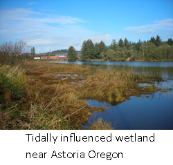
It is imperative to know what the constraints due to wetlands and streams are on a property before purchasing it. Some wetlands are obvious, although many are seasonal and not readily discernable, especially in areas of dense vegetation cover. Buffers on lower value wetlands may be as small as 25 feet, although larger wetlands commonly have a buffer width of over a hundred feet, with some exceeding 200 feet. Similarly, streams often have buffer width of at least 50 feet, with fish bearing streams commonly requiring a buffer setback of 150 feet or more. Specific buffer widths vary by jurisdiction. With the large buffer widths on streams and wetlands, there are now many properties that are almost or entirely constrained by wetland/stream and buffer. It may be possible to build on these properties, although the effort involved can be variable depending on individual site circumstances. There are some properties that are not economically feasible to develop, or that would require a lengthy and expensive permitting process to facilitate development. For this reason, find out the constraints, before you buy land or invest in expensive site planning.
A phased approach to a wetland study is often a good way to control costs while determining if a property will meet your needs. The first phase may include a walk-through of the property and general identification of wetland areas. In this phase, the client will be provided with a sketch showing approximate wetland areas and buffer setbacks and a memo summarizing development constraints.
Cost is variable and will depend on the size of the property, extent of wetlands and type of vegetation present. For example, properties that are covered by steep slopes and blackberry brambles take much more time than those that are mowed grass or easily walkable forest.
Wetland and Stream Delineation
Delineation of a wetland involves placing flagging at the edge of the wetland-upland boundary. Wetland boundary determination is based on federal Army Corps of Engineers wetland delineation requirements, and associated documentation that supports the delineation must be completed. The edge of streams are typically determined by marking the top of bank or the ordinary high water mark, which is interpreted by the state as the edge created by the two-year flood event. Wetland and stream delineations are summarized in a delineation report, which includes technical descriptions of vegetation, hydrology, and soil, as well as information regarding required buffer setbacks.
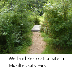
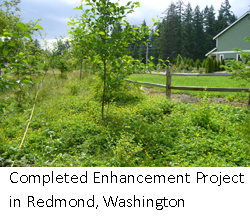
Mitigation
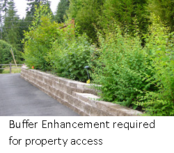
If it is necessary to fill a wetland or disturb a buffer, such as for property access, then mitigation will be required. A mitigation plan identifies areas of impact and how the project will replace wetland or buffer functions. The disturbance of wetlands, streams, or their buffers is typically allowed only when it cannot be reasonably avoided. There are typically several site planning options available, if needed. It may be possible to cross wetlands or streams to access property, reduce buffers, or average buffers, which involves reducing the buffer in one area and replacing it elsewhere. Whenever there are wetland, stream, or buffer impacts, it is necessary to “mitigate” the impacts. This requires the preparation of a report and plan that describe exactly where the impact is, how much area is involved, and what is proposed to off-set the environmental impacts of the project. It is required that we demonstrate how project impacts are avoided, minimized, and mitigated, if necessary. The mitigation required typically involves removing invasive vegetation and installing native trees and shrubs, or protecting higher quality vegetation elsewhere, either on the property or off-site.
Monitoring
After a mitigation plan is implemented (weeds removed, plants installed, etc.), monitoring is usually required for three to five years, depending on project complexity and local jurisdiction. This typically requires two site visits per year and annual reports that summarize the condition of the site. Monitoring typically includes identifying plants by species, counting them to determine if sufficient plants have survived, measuring their growth and providing maintenance recommendations to ensure project success. Aquatica can assist with monitoring and submission of reports to the County.
We serve the Greater Seattle area including King and Snohomish Counties and such cities as: Auburn, Bellevue, Bothell, Carnation, Des Moines, Duvall, Edmonds, Everett, Fall City, Federal Way, Gold Bar, Granite Falls, Index, Issaquah, Kent, Kirkland, Lake Forest Park, Lake Stevens, Lynnwood, Marysville, Mercer Island, Mill Creek, Monroe, Mountlake Terrace, Mukilteo, North Bend, Redmond, Renton, Snohomish, Snoqualmie, and Sultan. Travel outside of the greater Seattle area is also possible and can be arranged on a project by project basis.